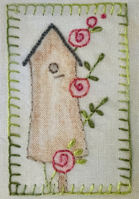
This morning's inchy has been stitched, and so the day is off to a flying start.
Tandem lap-sitting seems to be the new thing here at the Traveling Three Cats Ranch. Wonders never cease.
It's the first unplanned day we've had since arriving here in Pahrump, and so we're soaking it up this morning. But let's just back up to yesterday, shall we?
We had a beautiful day for our visit to the Red Rock Canyon NCA. This area is under the purview of the Bureau of Land Management.
Turning off the main highway, we passed by a gypsum mining operation on our way to the park.
These cliffs give a preview of what we were about to see. When I look at something like this, I wonder what happened geologically to give those layers of color.
Be on the lookout for wild burros...
and wild horses too, apparently.
We worried when we reached the gate. There were signs that said reservations were required, and we didn't have reservations. There were three long lines of cars waiting to pass through.
Fortunately, when we reached the gate, the man there had "reservations available," and so we paid an extra $2 for the reservation, and used our national parks pass to enter. And let this be a lesson: I've read and heard that many of the most popular national parks are now requiring reservations. When we visit in the future, I'm going to have to remember to check a park's website for this, and also to check for any other closures or restrictions we need to know about. I'm still smarting from Kasha-Katuwe National Monument being closed when we wanted to visit last fall.
We drove past the visitor's center, having been there the last time we came. We drove straight to the first turnout and got out for a look around.
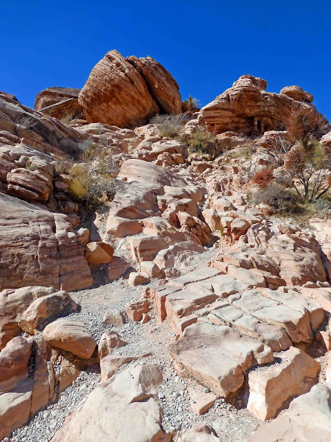
This is an enormous escarpment just about half a mile into the park. Here's a panorama of the whole thing.
Below is a worthwhile explanation. If you were following along on our trip last fall, you might remember we had similar questions about this
when we visited El Malpais National Monument, which is a national monument and a conservation area. The national monument portion is under the purview of the national parks system. Apparently the BLM is in charge of conservation areas.
At first glance it looks as if it was formed by glaciers, but there is more to the story.
This pile of rubble is at the southernmost end of the escarpment.
The striations of color in the rocks are the most interesting part of this park...for me, at least. It's something like the rings of a tree, only measuring geological time.
And while it looks glacial in origin, it is actually the wind that is responsible for the formations here.
There was a trailhead, but we kind of messed up trying to get on the trail.
We went in the wrong direction and ended up scrambling down this steep hillside for the views you're about to see.
There were dozens of climbers out on this day.
You can see one group in the image below. The climber is marked with a green arrow. A group below is marked with a red arrow. It gives you some idea the scale of the rocks here.
Here's a view closer up, and you can see about a dozen ropes strung for other climbers.
We spoke with a woman who was all decked out for climbing. She explained there are "bolts" already available for climbers to use, and they are not pounding or drilling any other equipment into the rock face.
Our shadow selves were amazed by the climbers. They were considering trying this themselves, but couldn't find any shadow ropes to use. Frankly, I'm not sure how dependable a shadow rope would be.
I liked the sign describing this as being like brush strokes created by wind.
Had we gone the right direction, we might not have seen an example of the "secret waters."
But here's a "tank" right here. Look toward the top of the image, and you'll see a woman peering down.
I only took this next picture because of the juxtaposition of the jet flying over these ancient rock formations. Later in the day, we looked up to see no less than seven jet trails. Las Vegas has a very busy airport.
This is desert holly. At a different time of the year, it will have red berries.
Here are some more examples of the colorful striations.
We saw plenty of these signs on the scenic drive, but no tortoises.
Driving on to the next overlook, this was our view to the north.
Here's a panorama of the same area.
Looking south, we could see where we'd just come from.
Looking west, it's a barren landscape.
This was all a vast field of sand dunes many millions of years ago.
We took one last look at the Calico Hills formation and then headed on to our hiking destination.
Mike chose the Keystone Thrust trail. It was to be 2.4 miles in and out (total mileage), and the elevation change was 400 feet. It was rated "moderate" difficulty in our hiking book.
We started by walking up a wide wash, and then heading off to the right.
We scaled this short stairway...
And then we just kept walking. It was uphill almost all the way.
We were following another couple. As we looked ahead to where they were, it gave us some idea how much farther we had to walk. They actually ended up getting off the trail and climbing to the top of this hill.
We could have done the same thing, but we were tired. When we reached this spot with a good view of the
Keystone Thrust, we turned around and headed back to the truck.
Along the way, I noticed snow on the back side of one of the hills off in the distance.
Throughout the park, we found these rocks with what appears to be "splatter," or "dripping." Clearly, there is iron in the rock, which has "rusted" and turned these spots red. We're not sure what accounts for that dalmation-like spotting.
Looking back from the parking lot, we got another good view of the "thrust," and you can see a half moon overhead.
As we drove back to Pahrump, we saw some larger views of
Mt. Charleston. And I'm just gonna say that Nevada likes its rusty metal scuptures.
We saw a grouping of about a half dozen wild burros, but I wasn't quick enough to get a picture. Instead, I'm sharing this image from
when we visited Oatman, Arizona, last year. This one was walking along the road.
Here are some of the ones we saw in town that day.

Just now I went to try to find a link about the wild burros of Nevada and discovered to my sheer delight there is a dedicated wild burro range just to the north of us called
Marietta Wild Burro Range, also under the purview of the Bureau of Land Management. Cool! I've been looking for a sight-seeing opportunity after we leave Death Valley and head for home. This just might be it! I've even laid in a course for home that includes a day to see the wild burros. Okay, so if I was travel weary five minutes ago, I just now perked up significantly.
Okay, but I haven't finished talking about yesterday yet. Please excuse my tangential thought process.
Before we left yesterday, I stitched the day's inchy. It wasn't hard, but it took a long time.
Here are the ten I had when I finished yesterday's stitching. As of this morning, there are ten plus one.
Okay, so it's time for me to get going on something else. With an unplanned day, the sky's the limit. I'll probably quilt the Rise and Shine quilt. I'd like to get the three little quilts finished so I can sew on their bindings. I have an idea I'm going to want some more hand sewing before we get home. And, if anyone is counting, home is still several weeks away.


11 comments:
"Congress finds and declares that wild horses and burros are living symbols of the historic and pioneering spirit of the West." ~ Wild Free-Roaming Horse & Burro Act, Passed by unanimous Congressional vote, 1971
What a beautiful place to visit. Thank you for sharing your photos.
I look forward to seeing you tiny stitcheries each day.
Boy, those striations are something--just amazingly beautiful...[can you see a quilt piece using that idea??] Your inchies are really coming along so fast!!
It looks like you really got around a lot of places...I also love those scrubby looking bushes--kind of like what you see on outer Cape Cod here in the NE!!
Thanks for sharing your day's journey here hugs, Julierose
The inchies are so very cute. I’m amazed at the colors and layers in the landscape. Wow!!
What a great place to visit, and those colourful layers in the rocks are amazing. Interesting Burros to see and a tortoise crossing, goodness!
Red Rock Canyon... The silence was deafening.... The only reason we wanted to go back to Vegas....
Thank for stirring some wonderful memories (again. lol)
Loving those inchies, they're looking really good.
Your little inchies are looking great! What a fun outing, with so many beautiful views. Have fun visiting the burros, too - that sounds like a fun day as well!
Often when driving through Beatty, Nevada (a bit north of you on 95), you will see wild burros. Love the deserts of Nevada and Utah - their beauty is awesome. Nothing like watching a thunderstorm roll across them, changing their colors.
Awesome rocks! And, whoa nelly, BIG. Very cool, thanks for the tour! Inchies are sweet!
That's a stunning park! Very cool scenery. Your Inches are looking good too.
I'll never get to Nevada so I'm enjoying visiting through the lens of your camera. Certainly some very large rock formations there.
Post a Comment