There was a pretty sunrise yesterday with pink appearing in the clouds outside our window.
Sadie was hard at work stretched out and warming Mike's lap.
We stopped in first at the visitor center. In my paranoia over parks being closed, I worried the visitor center would be closed. There was an alert on the website announcing temporary closure of the "ranger station," and I wasn't sure if there was a difference. Happily, it was open because we really needed a map of the place.
In the parking lot, I took advantage of an opportunity to photograph the blooming
rabbitbrush. Since leaving Colorado, we've traded Black-eyed Susans for rabbitbrush lining both sides of the road and blooming pretty much everywhere.
The Google tells us that Native Americans used rabbitbrush as a yellow dye, to make a medicinal tea, and for chewing gum. The forage value of rabbitbrush varies greatly among subspecies and ecotypes. In some locations, it can be an important browse species for mule deer, pronghorn, and jackrabbits during fall and winter. It also provides cover for mammals and small nesting birds.
Walking on, we saw a whole bunch of these guys:
Good thing I wasn't riding my bike, huh?
Oh yes, and watch where you're stepping. You could die out here...yes, right here in the parking lot.
I'll admit to being a bit confused about the actual name of the place. There are two units here: El Malpais National Monument is under the purview of the National Park Service. Surrounding the designated "monument" is the El Malpais National Conservation Area, which is under the purview of the Bureau of Land Management. My confusion cleared after a visit inside, listening to a ranger explain the park to some fellow visitors.
Our journey yesterday took us along the road you see in the image below...the one farthest to the right, and heading in a north-south direction. You can see that it weaves in and out of the boundaries for both units, but mainly stays right along the dividing line.
We stopped off at each site along the way, which made for a long day and a LOT of exploring. It was so beautiful, I couldn't stop taking pictures. I have so many pictures, I decided to break this post into two parts so as not to give short shrift to any of it.
Before leaving the visitor center, I took pictures of a couple of things I knew you'd want to see. First, this quilt block made from carpet tiles. This gives me an idea for a southwest quilt:
Also, with Halloween approaching, I knew you want some advice from a bat:
Okay, so let's just start with what makes this area worthy of "park" status. Here are some informational signs explaining the whole thing. I'll cut to the chase by saying it is made up of two different geologic formations: sandstone bluffs and a vast lava flow. It's the same flow I mentioned yesterday: McCartys Flow with a little more thrown in.
Before we go anywhere though, let's get the rules straight.
Ready? Okay, follow me. We headed down the paved road through the park(s), and turned off at the first point of interest: the Sandstone Bluffs Overlook. We traveled about a mile and a half on a gravel road to the parking lot.
We parked directly in front of this sign, almost as if it were posted there specifically for our viewing pleasure. Bummer.
Be safe, my friends. There's danger lurking around every bend in the trail.
This is the surface we were walking on.
Looking north, the views were spectacular. The heavy rains the day before had filled all these little pools with water, which made it extra special.
Even the sky was beautiful for yesterday's visit.
Here's some information about what you're seeing.
Looking south, the views were even more stunning.
At our feet were various lichens. Here are a couple of examples:
A trail guide informed us that there are thousands of lichen varieties worldwide. El Malpais is home to about seventy. Ranging in color from gray-green to bright orange, these lichens are found on much of the McCartys flow.
Lichens are a combination of algae and fungus and help to break down rocks by way of a chemical reaction between the lichen and the rock. The by-product of this chemical reaction makes the rock more susceptible to the elements and weathering. Lichens have been used by humans for everything from decorations to food. Neighboring American Indian tribes still use lichens as a dye for wool. One of the more interesting uses of lichen is to measure air quality. Because lichens absorb chemicals from the air and rainwater, they are very susceptible to air pollutants.
Looking farther south, this is what we saw:
From there, I looked north again.
Also, we passed by this geological survey mark. We often find these in our travels.
Looking straight out, we could see the vast lava flow that covers a huge swath of the state. Directly below was sandstone, but looking about halfway down in the image, you can see some ripples in the landscape, and that is where the lava flow begins.
Don't you suppose this little tree was happy for a drink of water?
Taking in one last view to the south, it looked like this. Just breath-taking.
From there, we moved on down the road to the next destination, and the first of three short hikes:
After parking, I looked across the highway to see this:
The trail we were about to take was actually more than 7 miles across, leading from the edge of the road we were traveling to the far side of the lava field and meeting up with one of New Mexico's state highways. Walking on the lava field is challenging, as I'll show you in tomorrow's post. For now, just know we decided to walk out to where we could see the lava, and then return to the trailhead. Here's a little about the trail.
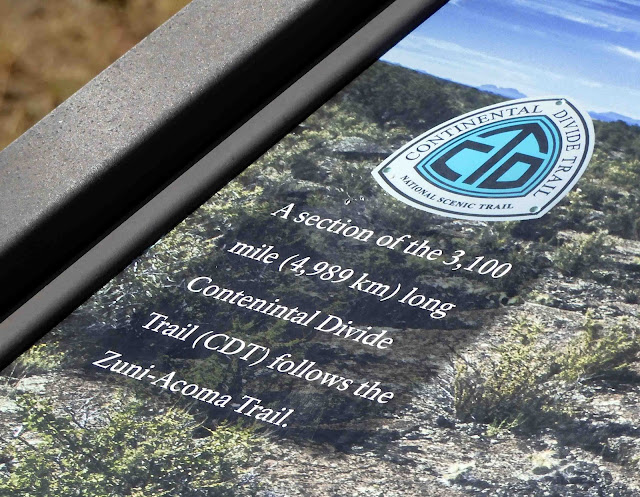
And just FYI, we walked a section of the Continental Divide Trail here. We were pretty sure this added to our already high score on the "badassery" scale. And we made up the scale, so we make the rules about it.
Our shadow selves were feeling pretty badass too. I don't think they realized a monster tree was stalking them.
The trail started out easy enough.
As I walked along, I looked for a good view of this monolith through the trees.
After walking around half a mile, we came to the lava flow part of the trail. The openings in the surface you see near the middle of the image are cause when gas expands the hot lava, like bread rising. It leaves a hole in the surface, something like the interior of a good sourdough bread.
Everywhere we looked, trees, shrubs, cactus, and wildflowers grew, against all odds, seemingly from solid rock.
We walked about a mile, and then decided we'd gone far enough to call ourselves "men." Then we returned to the truck to head on down the road. Along the way, we saw tracks like these. They are probably canine, but not domesticated. After the rains the day before, our footprints were the only ones on the trail, and I can assure you we did not bring any woofies with us.
I noticed this blooming cholla cactus.
Here's a close-up of its flower.
These bushes are all bloomed out, but I liked how the morning sun glinted off the spent flowers.
Okay, so tomorrow, I'll tell you about our visit to La Ventana natural arch and about our loop hike on the Lava Flows area.
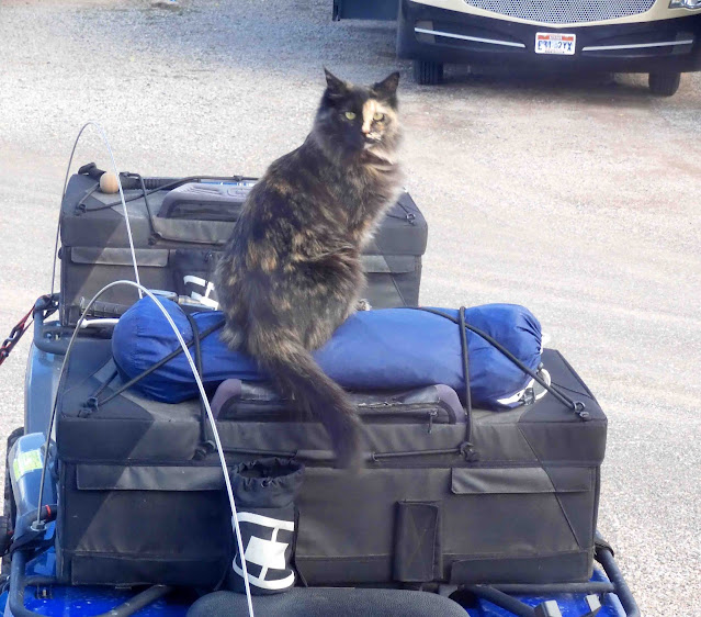
Before I go, I want to tell you about what happened as I was sitting at the table editing my pictures yesterday. I looked outside where our trailer is parked to see this:
And
holy sh*t! I thought Sadie got out somehow, and that would be very bad! Oh, but then, I noticed the tail...too long to be Sadie.
And this little girl made herself right at home. She spent the next hour or so thoroughly exploring the trailer and the ATV's loaded thereon, just as if she owned the place.
As a matter of fact, I do own the place.Okay, so that was entertaining. I tried to get Smitty interested in this intruder,
but he was not impressed. Torties are so commonplace, you know.
As for today, we planned this as a free day. We're going to just laze around. I'm planning to bake a skillet cookie. After all that hiking yesterday, I think we've earned one. We're expecting heavy rain. If it isn't too much, I might try to get some laundry done...or maybe not. It's all up in the air at this point. I think we're both ready for a day of rest.


9 comments:
Earth is ancient now, but all knowledge is stored up in her. She keeps a record of everything that has happened since time began. Of time before time, she says little, and in a language that no one has yet understood. Through time, her secret codes have gradually been broken. Her mud and lava is a message from the past. Of time to come, she says much, but who listens? ~ Jeanette Winterson
What an amazing place to see. This planet of ours deserves a lot more respect than we are giving it.
What a fun place to explore by truck and on foot. I love all the views and history you shared. That first picture of the tortie had me fearing Sadie had gotten outside too! I'm sure your heart did a flip at first. That cat certainly did own the place. Watch out as I bet the one will happily come inside to say hello to your kitties.
What an amazing country we live in. And what an amazing person you are to take us all along on your trips. I can't thank you enough
What an interesting day and hike. I thought that was Sadie too, until I noticed the tail!
Stunning scenery.
Once again, I'm fascinated. Not only by the rock formations but also the plant life which is so very different from what we have here. I chuckled when I saw the fly on the rattlesnake - don't think he'd want to perch on a real one!
Back many years while traveling with my Mom we stopped at Acoma Sky City. Just saw a sign on the highway and decided to check it out, and took a tour. No pictures were allowed and we weren't allowed to take our personal vehicle. A very mind expanding tour. I'm not even sure at that time it was called the same name. Memories are a bit fuzzy with no pictures to help remember. It was our favorite way to sightsee when traveling to and from visits to family. We did talk about Acoma for years.
Oh, my a kitty imposter! Quite a scare! But wait, the tail, and the face!
Post a Comment