Good morning, my friends. It was a banner day yesterday. We headed out to Panguitch to see the things I wanted to see there. It's a small town, and so we were finished there before lunch time. We decided to head back to the RV and stop off at a hike we'd seen along the way: Mossy Cave. Smitty got out for a walk when we got back to the RV. So with all that going on in a single day, you might know that I have a pile of pictures for you. You might want to fill your cup with whatever your drinking. You'll want to stay hydrated for this.
As we left the RV park, we saw this:
Just outside and across the highway is this formation.
The drive started out in this pretty valley. There are farms and ranches in this part of Utah.
And there are a few abandoned structures.
I thought this next one was a barn, but then I read what it says on the roof: Bryce Canyon Airport. I can promise you this is a small airport.
Heading down the road, we crossed the boundary into Bryce Canyon National Park. The gate and visitor center are some distance away, but the park boundary extends out in all directions from there.
Mike thought these looked like groomed slopes.
And we passed through that double-delight of tunnels again.
We'll pass through them one more time before we finish here.
Continuing on, we passed through Red Canyon.
When we emerged from the canyon, it looked like a different world.
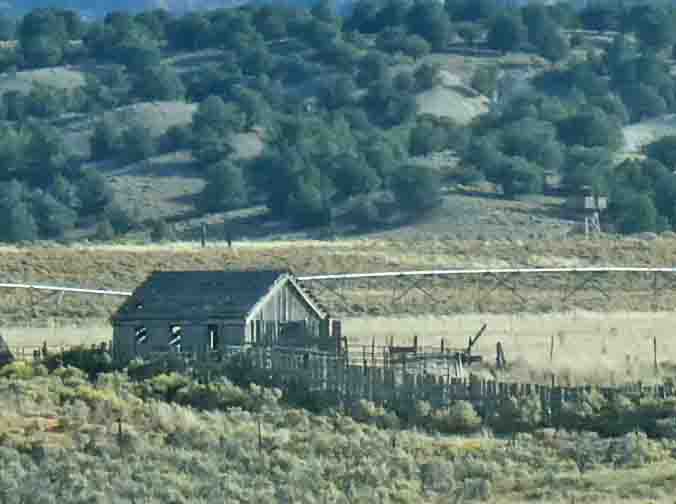
We passed by a few more abandoned structures.
And a few miles down the road, the town of Panguitch came into view. Panguitch is the county seat for Garfield County. It's 2020 census put the population at 1,725 people.
We were here for two reasons. First, I can't remember when or where I first heard about the Panguitch Quilt Walk, but it's been on my bucket list for a long time. I'm going to link to the story one more time, and I encourage you to read it. What comes next will make a lot more sense if you do. So heroic were the efforts of these Mormon settlers that a park has been built in their honor.
Here's a sculpture depicting their actions.
Here's a detailed shot of the quilt he's holding.
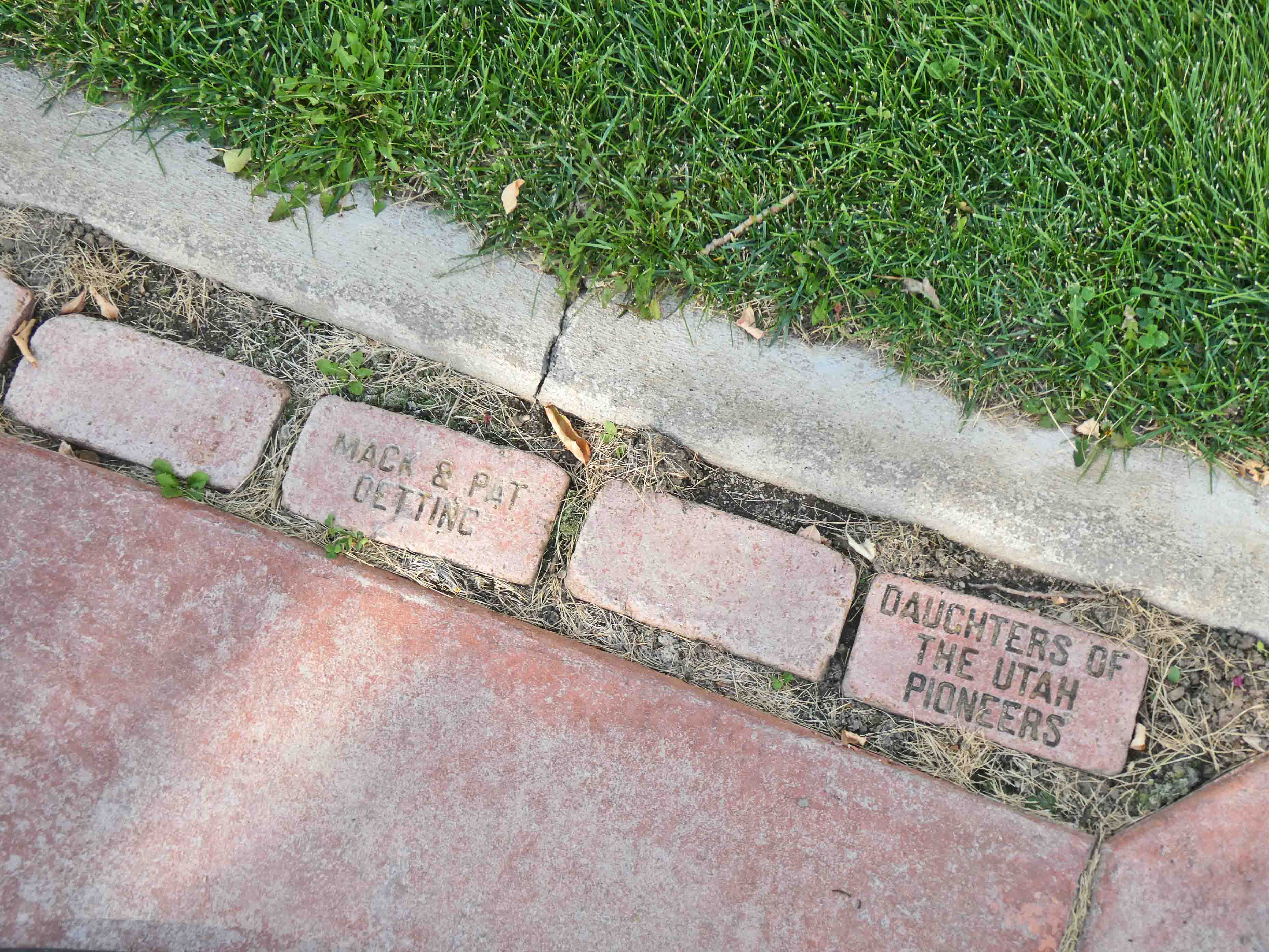
Behind him, this red walkway.
The edges of the walkway are lined with bricks, some including names of volunteers or donors.
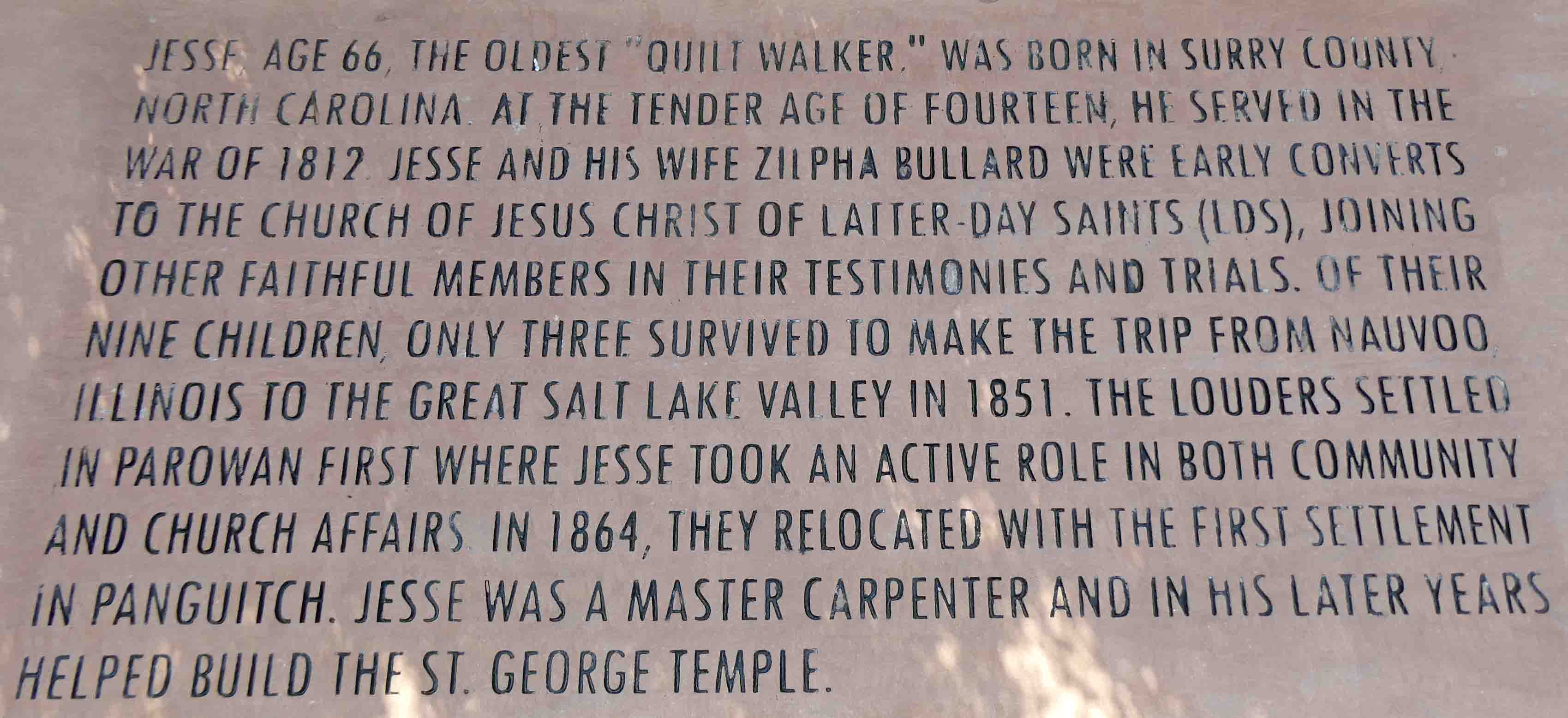
Seven men completed the quilt walk. There are seven benches honoring each individual. Their names are carved in the edge of the bench, and a short bio is included on the seating part of the bench. I took pictures of all of them, and I'll let you read them. It included men from all over, and from all walks of life (no pun intended).
The walkway and areas beside some of the benches were decorated with this quilt block:
Okay, so our second goal was to visit the quilt shop. Most of the town can be seen on two streets: Main Street or Center Street. The quilt shop was on Center Street. Standing at the corner, I took this photo. The quilt shop is the wooden structure in the middle.
Crossing over, I took this photo of the opposite side of the street.
We had just a short walk to reach Patches Quilt Shop.
Mike took a seat on the bench outside, while I went inside to shop.
I'll tell you more about the quilt shop in a separate post. It was only about 11:15 a.m. when we finished with our sight-seeing in Panguitch, and so we headed back to the RV. As we left, I noticed this "Social Hall," established in 1890. That "tank" in front says "Panguitch Fire Department" on the side.
There were also a couple of rustic sculptures as we drove out of town. Here's a stagecoach. Sorry about the glare on the window.
Also, this mule hauling a rail mine wagon car.
As we drove out of town, I noticed this patch on the mountain where the leaves have mostly turned.
Heading back, we were at the beginning of Scenic Byway 12, which is listed in my scenic highways and byways book. The road extends for some 100+ miles. We're only traveling a small portion of it.
We'd driven by a parking lot for Mossy Cave several times. It was well before lunch, and so we decided to park and see what this was about. The hike was less than a mile round trip.
You'll have to park your woofies somewhere.
We made a brief stop at the facilities and then headed on up the trail. We're within the boundary of the national park here, and the views are every bit as spectacular as you might imagine.
The trail took us across two bridges.
Here, you can see the stream. The water was a light aqua-green...almost like glacial run-off.
Here's a little more information about the canyon.
I took this picture so you could see how erosion has removed almost all the soil from around this tree's roots. We saw many trees like this and more than a few that succumbed and fell.
Here we crossed the second bridge. Notice how the bank on the right has been shored up, and then eroded some more.
Shortly after crossing the second bridge, we came to a t-intersection and this sign. To the left was the cave. To the right was the waterfall.
We decided to go to the cave first.
The sign there showed how ice forms in winter.
There was no ice yesterday...just plenty of moss. I'm hoping you can see how much water drips from the top of the cave. You can see the drips in the vertical white streaks in the image below.
From there, we went back the other way to see the waterfall.
There was a small dribble of a fall here, but this area is closed. Please avert your eyes.
If you're wondering about that, it looks as if the trail once passed along the edge there, but erosion has made it unsafe. The trail routes around that area now. And here's the waterfall.
Of course, moving water is always more interesting in video form, and so I made this video with my phone. If you can't see the video, click right here.
Looking up from there, we could see some small arches in the rocks above.
Here's some information about how the water was diverted to this canyon.
As we walked back to our truck, I noticed the changing leaves. This is a smallish shrub.
And I liked this view through the trees.
Check out the work of woodpeckers on the tree there.
From there, we headed back to the RV. Our neighbors with the two woofies were gone somewhere, and the rest of the park had cleared out of overnighters. It was a good time to get Smitty out for a walk. On this day, I picked him up and carried him to the path that leads to the wash behind us. He sat and considered the advisability of continuing.
Eventually, I encouraged him by walking ahead and beckoning, "Come this way." He complied, somewhat reluctantly. Just FYI, it's not a good idea to walk ahead of a cat that's leashed and harnessed. They can easily slip the harness from this position. Smitty has escaped a couple of times, but he has the good sense to run back to the RV. On the other hand, Sadie runs away.
As we walked along, he found some Mew-tah grass that was more to his liking.
And this is some sort of evergreen sapling. He thought this was delicious. We spent a good five minutes nibbling at it.
While we were there, two people leading two woofies passed by us on the path. I knelt down and got a good grip on Smitty, reassuring him with "It's all right. Stay cool." The people were kind enough to recognize the problem and headed off in a different direction. Smitty got extra treats of valor when we returned to the RV for his bravery in the face of certain death.
And then a pretty big storm blew in. We had high wind and rain off and on for most of the afternoon, and then a lot of rain, thunder, and lightning last night. The rain has stopped, but we have dueling forecasts for the day. One forecast says no rain. The other predicts rain between 11:00 a.m. and 2:00 p.m. Mike is still sleeping as I'm writing this, and so we haven't really talked about what this means for our day.
Originally, our plan was to visit Kodachrome Basin State Park and do a short hike there. It's another one of those red rock parks, and so it will be more scenic in the sunshine. Our other plan (for tomorrow) is to hike a slot canyon at Willis Creek Narrows. There's less chance of rain tomorrow, and I'd rather not be hiking in a slot canyon in the rain. So we'll have to figure out one or the other for today. The state park gets my vote. For now, I'll wait for Mike to get up, and then we'll figure out what the day holds. Until then, I'm sure you'll be waiting on tenterhooks for our final decision. More tomorrow.
So, I'll be back a little later to tell you about the quilt shop. Until then, have a nice day everyone. The shutdown has been averted. We, in America, can breathe just a little easier this morning.
Whether in cave paintings or the latest uses of the Internet, human beings have always told their histories and truths through parable and fable. We are inveterate storytellers. ~ Beeban Kidron
Quilt Walk park was fascinating to read about, I felt like I was walking along with you thanks to the pictured. We haven't explored this part of the country yet, but you have sure given me some good ideas for the future!


5 comments:
Whether in cave paintings or the latest uses of the Internet, human beings have always told their histories and truths through parable and fable. We are inveterate storytellers. ~ Beeban Kidron
we took that same hike the last time we were out there - not a really long hike but the scenery sure is pretty - I loved seeing the arches there too
Smitty, you are a hero. I'm proud to know you. And you are alive!
Beautiful scenery.
Quilt Walk park was fascinating to read about, I felt like I was walking along with you thanks to the pictured. We haven't explored this part of the country yet, but you have sure given me some good ideas for the future!
Brave Smitty!
Fascinating to read about the quilts and how brilliant and also brave those men were.
Post a Comment