Good morning, my friends. I'm happy to say we still have internet access here in Vernal. We're practically right on the main highway, and so it isn't surprising. It's also fairly noisy. Oh well. It was quiet enough for a good night's sleep.
We drove through three states yesterday. As you can see, Sadie was completely stressed out at the thought of another day of driving. Actually, I think she was hoping we'd get going so she could get her morning nap.
Devils Slide is a classic example of how different rock layers, depending on their composition, are affected by weathering and erosion. The sides of the slide are hard, weather-resistant limestone layers about 40 feet high, 25 feet apart, and several hundred feet in length. In between these two hard layers is a shaly limestone that is slightly different in composition from the outer limestone layers. This middle layer is softer, which makes it more susceptible to weathering and erosion, thus forming the chute of the slide.
A river runs past at the base of the slide. On the other side of the fence, I noticed these wildflowers growing. It seems all the wildflowers are yellow at this time of year.
Utah has its own share of abandoned structures.
As we passed through a notch in the Wasatch Mountains, we came upon the red rock that is characteristic of much of Utah's lovely landscape.
We crossed over into the southwest corner of Wyoming for a bit.
The road was terrible here, but the landscape was interesting. Incidentally, the road was bad enough that it caused the clothing rod in the closet to come lose. Our clothes are currently sitting on the floor of the closet. Mike will be able to fix it today. We agreed if that's the worst thing that happens this trip, then we'll be happy campers.
Just after crossing into Wyoming, we came on Fort Bridger State Historic Site. I only just barely caught a few of the structures as we passed by. We still had far to go, and so we didn't stop.
You can read more about it and see some videos and pictures at the link I've given you. But briefly...
Fort Bridger State Historic Site maintains and interprets historic structures and remnants from its 5 eras of occupation which include the Mountain Men, Mormons, Military, Milkbarn/Motel and Museum. The site also interprets the many trails that came through Fort Bridger including the Oregon Trail, California Trail, Mormon Pioneer Trail, Pony Express Trail, Overland Trail, Cherokee Trail and Lincoln Highway.
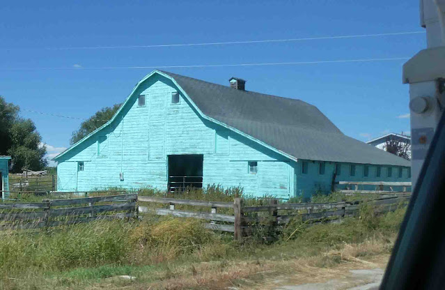
Just after passing Fort Bridger, we came upon this barn of a different color...swimming pool blue.
We were approaching the Flaming Gorge-Uintas National Scenic Byway. As we grew closer, we started seeing some of the Navajo sandstone from the Jurassic period. It's hard to tell in this image, but the lighter portions were tinged with green, indicating the presence of copper.
Just a little farther down the road, we crossed back into Utah again.
As we topped a rise, we could see the water that fills the Flaming Gorge Reservoir at the Flaming Gorge National Recreation Area.
Here's how it looks on the map. The reservoir is 93 miles from top to bottom.
We caught glimpses of it as we drove along. I was giving us a guided tour from our "Guide to Scenic Highways & Byways" book.
Eventually, we came to the turn off for the Red Canyon Visitor Center, and so we drove back in and off the highway for about a mile and a half. We were fortunate to find the visitor center open where we could get some beautiful views and learn a little more about the place. This was the view from the window of the visitor center.
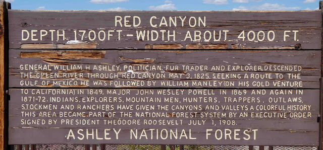
This informational sign was posted just outside the window.
Here's another sign posted inside the visitor center with a little more information. It's hard to read, and so the images that follow are cuts from the original, making it a little easier to read (I hope).
Outside, there was a short loop trail. Before we go, let's get the rules straight. You could die out here.
Please get a good grip on your children. On the other hand, if you don't like your children, there are endless opportunities here.
Speaking of crevices...there's one right in the middle of the image below.
Walking to the end of the short trail, this was the view looking south.
Here's a little more information about the canyon.
Looking north, this is what you see. My thanks to those boaters for providing scale.
Here are a few more informational signs about the area.
This next image was captured as we walked back to where we were parked. It looks south. I walked near the edge of a cliff to look over the side.
As we walked back, we found more informational signs.
Looking up at the tree, you can see the holes drilled there by woodpeckers.
Here's yet another view looking north.
These grasshoppers accompanied us on our walk. They make a loud repetitive snapping noise when they fly. It's loud enough to startle you if one takes off right beside you.
We read this information about the reintroduction of bighorn sheep to the area.
And then, we were thrilled to find a group grazing along the roadside as we drove back out to the main highway.
The one showing you his better side below was reluctant to give up his primo grazing spot.
We inched closer and closer until he moved out of the way.
And oh happy day! I scored my first refrigerator magnet of the trip.
We traveled the scenic byway the rest of the way into Vernal. Along the way we stopped here at Windy Point. It was windy there...go figure. I hopped out and took a picture of the colorful landscape.
This next image is a zoomed in shot of the area on the right-hand side of the image above...right in the middle. It's an active open-pit phosphate mine. The phosphate-rich rock, used for fertilizer, originated from the decomposition of billions of microscopic marine organisms some 225 million years ago.
Also, I noticed this flag, which appears to be mounted in the remains of an old structure. I'm not sure what or why, and I could find no information about it.
We were nearing Vernal by that time. We've checked into the RV park. It's quite noisy here, being located on the main highway.
We added something new for the kitties this trip. When we're in our fifth wheel, they have their window hammocks where they can lie and look out the window snoopervising the goings on. For this trip, we brought along the Trashy Triangles quilt. When we're not using the table, we lay it there for them to lie on. The table has always been off-limits, but we're calling this area a "yellow light" area. (Think traffic signals and their yellow light.) When the quilt is lying there, they have the green light to lie on it and look out the window. They were a little confused by this the first few days, but they're both settling into it now that we've been on the road a while. Sadie used it to give herself a good licking down after so many miles on the dusty trail.
So we're here in Vernal to visit Dinosaur National Monument. Today we're taking a "chill day" after driving, driving, driving for three straight days. We'll just hang out and avoid getting in the truck today. We'll visit the monument tomorrow. We'll also need to do some grocery shopping while we're here. Our next stop will be at Taylor Park Reservoir in Colorado. It's a remote area, and there are no nearby grocery stores. We'll want to stock up on groceries to make it through the next week.
There are some pamphlets in the office here. One describes a walking tour of "vintage" Vernal, and so we might get out for a walk this afternoon. So far, we're just taking it easy, and we're all glad not to be driving anywhere today.


9 comments:
Well, we’re not in the middle of nowhere, but we can see it from here. ~ Thelma & Louise
Your breakfast looked good anyway 😋! Beautiful scenery and looks like the cats are enjoying the trip😻
I love your description of the barn being “swimming pool blue”. I never would have thought of that ... but it’s so true! Good one! Enjoying the ride ... thanks! Candy
Stunning views! Enjoy your day off....
Thx for sharing. I've never been in that area.
The views at Flaming Gorge are spectacular.
Thanks for sharing the pictures of Utah (my home state). The made me home sick, I live in TN now.
Such interesting scenery and places. Though I don't envy you all that driving.
I always love your vacation photos!
Post a Comment