Good morning, my friends! Well, what can I say? It was another day of jaw-dropping scenery and me not being able to stop my shutter finger from firing away picture after picture after picture. I've tried my best to whittle them down some, but it's hard to do. As I'm writing, I'm surrounded by kitties who are 'zhausted after spending so much time helping me with those pictures. Sadie is lounging on Mike's lap:
Smitty found our bed in disarray, and so he built a little nest for his sleeping pleasure.
Getting back to yesterday, let's start with our drive up to the turn-off. I've shown you quite a bit of the area in yesterday's post. Just across the highway from the turn to the national monument/park is "Church Rock." We could see it from miles away.
Making the turn, we passed by some abandoned structures.
Just a little way down the road, I noticed this rustic paddock. We talked a little about this. Is it in use? Is it abandoned? This is BLM land here, and the BLM is both praised and scorned for its wild horse round-up. We wondered if this was one of the paddocks they used. And there were others in the area too.
A little farther on, we came to one of the sites we'd planned to visit:
This is the whole of the rock. We stood here gazing at it for quite some time.
I'm including some close-up images of the symbols we thought were most interesting. These feet, for example. Why do some of them have six toes?
This one appears to show a person holding some sort of weapon in his left hand. Is he preparing to club that bighorn sheep?
Here, someone on horseback is firing an arrow at a deer or an elk.
Here's a family of bighorn sheep.
I looked at this one for a while. The curvy line represents a snake, but look at that little person on the left. Was a child bitten by a snake? Or someone else?
Finally, this one. I loved all the details in the antlers.
Moving on...we drove into some stunning scenery. I took picture after picture.
In this next image, those two conical formations on the right is the iconic image of Bear's Ears.
Here's another picture of one of those conical formations. Look at how thin and fragile that spire appears.
The road dead-ends after some 30 miles. About 3/4 of the way in, we crossed the border into Canyonlands National Park.
I learned something new about Canyonlands this trip. We've visited at least three times previously, but always at the visitor center located north of Moab, known as Island in the Sky. Our visit this time was to The Needles. Before this, I'd always thought the "needles district" was just a casual way of describing this portion of the park...which it is...but there's also a visitor center here. It's almost as if the two are completely separate entities since one can only visit both by leaving the park and driving the main highway to the other section...a distance of around 100 miles.
Crossing the boundary between national monument and national park, we saw this enormous formation. I never get tired of the colors of the landscape in this part of Utah.
We checked into the visitor center for any information about ATVing we could glean. While there, we found the guidebook we needed. I hated to spend the money on a book we already have at home, but we forked over payment for another. It was a worthwhile purchase to plan our riding. I'll probably sell one of our two books when we get home. Also, I enjoyed reading this "Advice from a National Park"
And this "Advice from a Canyon."
We sat outside for a bit while Mike studied the guidebook. I took a little walk around the short nature trail there. This is how the Black-eyed Susans look when they're bloomed out.
Continuing on, we came to this Wooden Shoe Arch formation. Here's some information about it:
Looking out across the landscape, you can see it there on the right.
Here's a zoomed-in shot.
Driving on...more colossal formations.
There was a short trail to view the potholes at this next turn-out. Here's a description:
Rock cairns guided our path across this slab of rock.
Here's a good example of the potholes. The largest of these is about two feet across. There was no water in them on this day, but it's easy enough to see where it accumulates.
Walking to the edge of the canyon, we could see this. Look way off in the distance and you can see "the needles."
There was plenty of prickly pear cactus in this area with "pears" for harvest if you're into that sort of thing.
Just now, I went in search of some information about how to use them. I've had them as a prickly pear margarita (which was delicious), and we've also had prickly pear syrup. This video talks about how to eat them. (If you can's see the video, then click right here.)
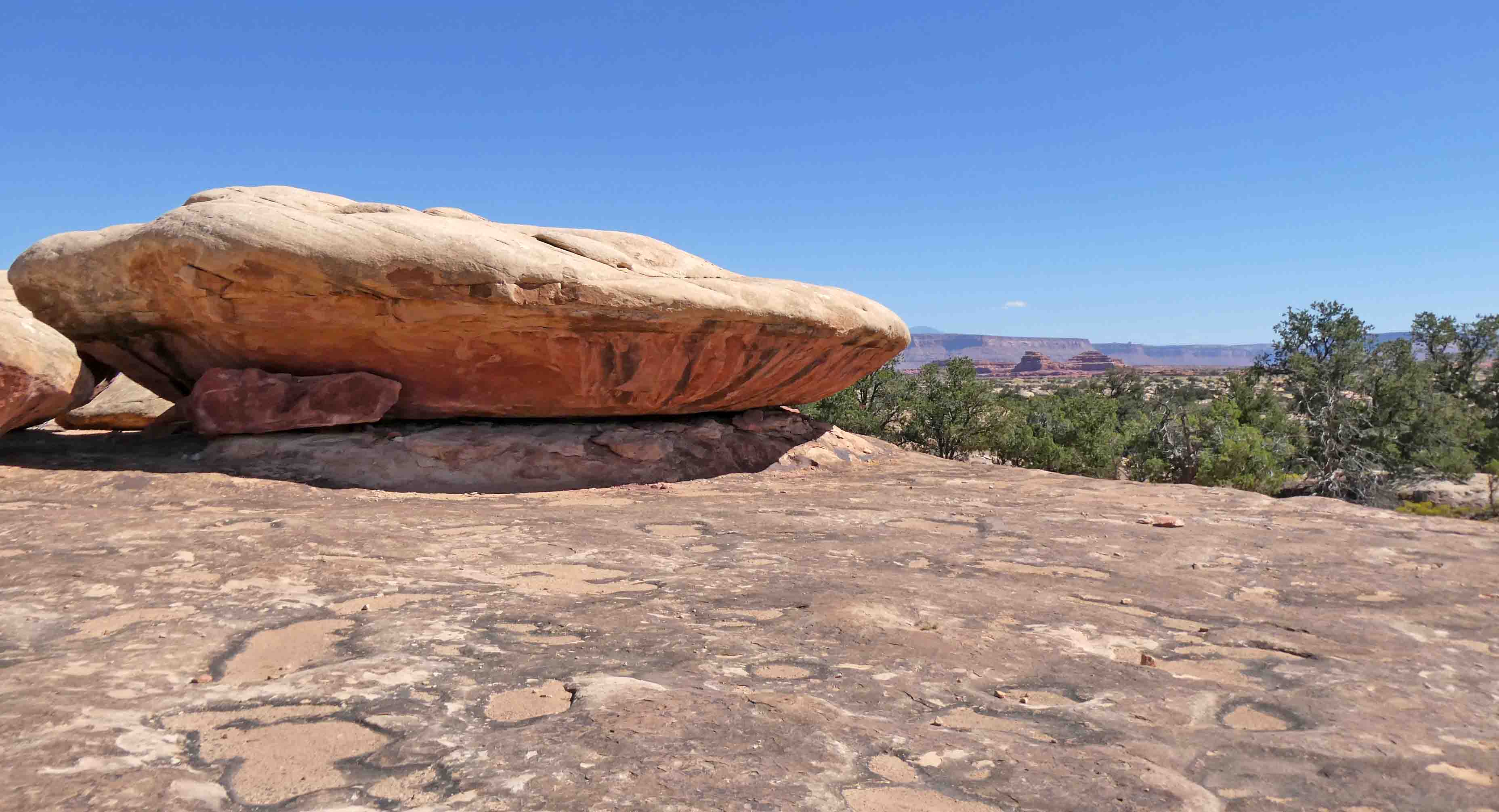
This was a short, but interesting trail. As we approached the end of the loop, we came across some immense boulders.
I had Mike walk among them for scale.
Oh yes, and we were fairly certain this is the fossilized (or petrified) remains of a flying saucer. Try changing my mind if you like.
Reaching the end of the road, I enjoyed the information on this sign. Canyonlands National Park was designated by President Lyndon Johnson. It's a pity Johnson is mostly remembered for escalating an unpopular war, but he actually accomplished a good bit of stewardship of both human rights and public lands while he was in office. The First Lady was also instrumental in the beautification of public spaces and made it her mission while Johnson was in office.
There was another short hike here. These are some of the things we saw.
In the image below, you can see how water has cut a canyon and created a waterfall. The canyon starts at center left, and then curves around to where it would fall if we could see water flowing (just left of center), and then continues curving to the right side of the image and beyond.
Of course, we had to take the requisite selfie here. #ihateselfies
From there, we returned the way we came. We'd skipped this turnout on our way in, and caught it on our way out.
These wild asters are ubiquitous in this part of Utah.
Walking on, we encountered the granary described in the sign.
The overhang would have kept their cache of food dry, and the wall would have protected it from animals.
From there, we drove back to the RV. We both were in dire need of a nap.
For dinner, I tried something new in the form of these Loaded Cauliflower Bowls. They're low calorie, and easy to make. I took the suggestion included in the recipe and added some roasted shrimp to ours. Otherwise, I made them just the same way. (This is the picture from the recipe.)
So we've planned the ATV riding we want to do. Our original plan had us riding today and taking tomorrow as a day off. The weather is forecast to be cloudy and cool all day, although there is no rain in the forecast. Tomorrow is expected to be sunnier and warmer, and so we've decided to take our day off today and ride tomorrow. It will give me a good amount of time to work on my slow-stitching. We'll probably get out for a short walk to see what we can find in Monticello. I have a feeling there's much more to the town that what we can see from where we are. If we can find a time in the day with no woofies or Mans walking by, we'll try to get Smitty out for a walk too. Also, I haven't forgotten I owe you a quilt shop post, and so I'll get that written today. Even on chill days, there's plenty to keep us busy.
Maybe you weren't born with a silver spoon in your mouth, but like every American, you carry a deed to 635 million acres of public lands. That's right. Even if you don't own a house or the latest computer on the market, you own Yosemite, Yellowstone, the Grand Canyon, Golden Gate National Recreation Area, and many other natural treasures. ~ John Garamendi


6 comments:
Maybe you weren't born with a silver spoon in your mouth, but like every American, you carry a deed to 635 million acres of public lands. That's right. Even if you don't own a house or the latest computer on the market, you own Yosemite, Yellowstone, the Grand Canyon, Golden Gate National Recreation Area, and many other natural treasures. ~ John Garamendi
Beautiful photos! Thanks!
That fossilized spaceship must be what brought the six-toed people to the area.
Mmmm,the loaded cauliflower bowl looks yummy!
Teresa F.
Just WOW on the photos! How can you not take shot after shot when you've got that kind of scenery. Enjoy your down day today.
Those "charms" are zipper pulls- I believe they are from Lori Holt and go with a series of zipper pouches that she designed.
Awesome photos! Thank you for sharing.
Post a Comment