
We only had about a hundred miles of driving for the day, but the final five miles were driven at no more than 10 mph, so it seemed longer. We enjoyed the last of the undulating hills near Bakersfield as we started the day. At this time of the year, there is even some green on the hillsides.

As we approached Tehachapi, there was snow on the hillsides. This is a big wind power producing area.

Moving east toward Death Valley, we found many square miles of solar farms. It seems each time we travel, we find more new infrastructure for renewable energy, which is a hopeful sign.

This trip, we've been making use of the Waze app for navigation. It's fairly helpful since it's crowd-sourced and warns us of any hazards ahead, including police presence, accidents, cars on the shoulder, road construction, and the like. On this particular day, the "Waze girl" (as we've taken to calling her disembodied voice), got pretty excited to tell us we could take this cut-off to save 7 minutes off our driving time. We're always suspicious of these time-savers since the cut-offs tend to be poor roads. This one was pretty good...a little undulating, but nice pavement. Ahead, we could see the Panamint Range. The highest peak on the left is Telescope Peak. When we are in Death Valley, we will be on the other side of this range.

Moving along, we thought we were beginning to see the first signs of the tusa formations.

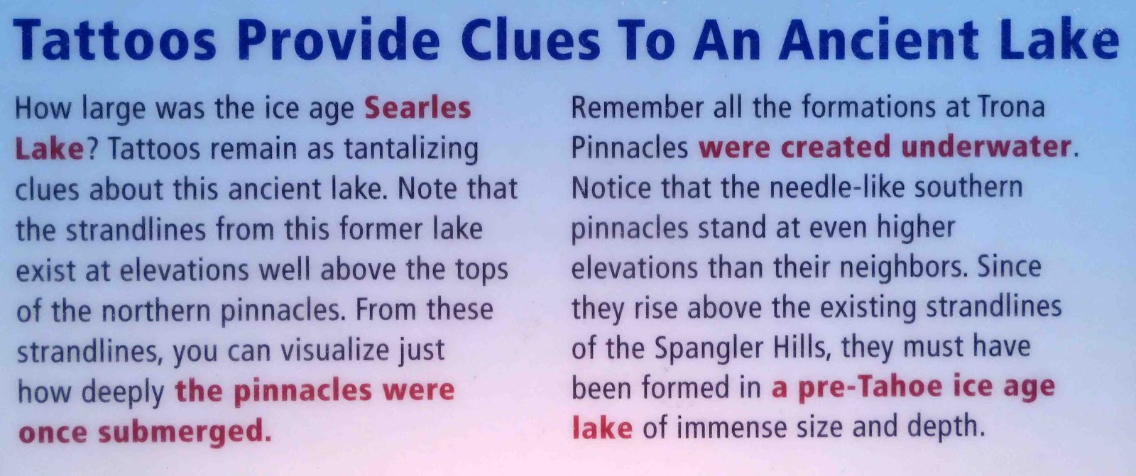
If you want to learn more about the Trona Pinnacles, I can recommend a visit to its Wikipedia page right here, where a good bit of information will be revealed to you. Here's a gist of it, cut and pasted:
During the Pleistocene, massive runoff spilled from the Sierra Nevada into a chain of inland seas. The system of interconnected lakes stretched from Mono Lake to Death Valley and included Searles Lake.Deep beneath Searles Lake, calcium-rich groundwater and alkaline lake water combined to grow tufa formations. Similar (modern) formations can be found today at Mono Lake to the north.Known as tufa pinnacles, these strange shapes formed underwater 10,000 to 100,000 years ago. The pinnacles did not all form at the same time. They are divided by age and elevation into three groups. The groups are dubbed the northern, middle, and southern groups because they formed during three ice ages. (Source)

For comparison, here's a picture I took as we drove by Mono Lake some years ago.

Eventually, we came to the sign directing us to the dirt road that would take us out.

As if heaven sent, we met up with a fellow RVer at the turn-off who encouraged us to continue. He said the road was as wet and as bad as he'd ever seen it (from recent rains), but that we should be able to make it with our rig. When he drove on, I took pictures of the informational signs there. Interesting stories both.

Remember you can always make an image larger by clicking on it.

And off we went...slowly, slowly, slowly. Mike was very brave. The road was washboardy, and we stayed out of the wet areas as much as possible. Although slow-going, it was easy enough. Nothing even fell down in the RV, which is saying something.

I took a picture of this next sign as we were parked at the "You are here" section, but we actually ended up camping where I've drawn the red circle.

Here are some more informational signs. This first one captions the one below it.


And this next one captions the one below it.

The tan profile above corresponds to the pinnacles in the image below to a certain degree. This was our view as the sun was setting.

At my feet was one of my favorite desert plants...the desert holly...or Atriplex hymenelytra, if you must know its snotty botanical name.

We pretty much have the place to ourselves, although there is one van off in the distance. I took a panorama so you could see the entire landscape. Of course, my shadow self had to photobomb me.

It's so beautiful here...and interesting. I'm itching to get out and do some hiking today.

The plan is to stay one more night and then head out again in the morning. There is no fresh water here.

We started our journey with a full tank of water, but (and without a long explanation) there is a kind of a design flaw on our rig related to an overflow valve on our fresh water tank. As we go down the road, over hill and dale, we lose about 1/3 of our fresh water just going down the road. Mike has an idea about how to fix it, but for now, it will necessarily limit our boondocking.

The kitties rested comfortably side by side on their window perches for the first time yesterday evening. Driving days are tiring days for kitties. So far, they've only been willing to use them one cat at a time. Apparently when kitties are tired, peace rules the day.

So we'll get out and do the driving and walking tours today, and I'll have more to tell you in tomorrow's post. I'm just so excited to be here blogging at all, there's just no telling how long I'll be able to yammer on. I hope you have lots of coffee.
I'm on generator power, and so this is my first act of the day. On the positive side, there are no quiet hours when one is boondocking, especially when one has no neighbors. I only mention this because we can run our generator until we get tired of hearing it, or until our propane runs out, whichever happens first. Temperatures dipped into the 20's overnight, but we're expecting temperatures in the low 60's and plenty of sunshine for our day. I'm hopeful of getting Smitty out for a walk, but the terrain is covered in sharp rocks. It might be hard on his feet. We'll see when the time comes.
10 comments:
Beautiful, and of course another place I've never heard of. Fascinating that they were formed underwater. You are one of my favorite natural science teachers. :)
What a strange and beautiful landscape--Amazing to read about the formation under water...and that they are still intact...
thanks for the virtual journey...hugs, Julierose
I am so happy to be riding on your back bumper for this new adventure. Thank you for taking me along-with everyone else :-) Amazing trips you all take :-)
This is a really interesting post. For a moment I was back in Death Valley (TV series) mode which Terry watches every day. The history of this earth is amazing.
xx, Carol
So I should maybe get out my 12-cup coffeemaker? :-D You two find the most interesting places to go to! I have to admit, that campsite had a beautiful view. The holly was interesting too. Hope you were able to do some hiking!
WOW! I have never heard of anything like this. Maybe because I live in the flat flat Midwest. Our local state park has oil under the lake which was pretty fascinating for me. I'm really enjoying your trip along with everyone else.
"Sew" happy that you are sharing your holiday with us once again. Looks like an interesting spot to hang out at for awhile. And without a lot of other folks, makes it extra nice. Maybe Smitty is going to have to get some kitty hiking boots to protect his tender tootsies!! :D Enjoy yourselves!
I spent my first 56 years in California but have never been to Death Valley. I'm really sorry now after seeing these pictures.
Death Valley is simply amazing!! Perfect time of year to explore it! Thanks for taking us along for the easy ride!!
Very Interesting. Thanks for all of the information!
Post a Comment