Showing posts sorted by relevance for query Breckenridge. Sort by date Show all posts

9/6/19

A Dinosaur Day

The kitties have done so well on this trip. There have been no escape attempts, and they have been very relaxed despite everything that has happened. When we left Vernal yesterday, they were snug in their cubby. Smitty was in the middle, and they're now sharing this space with no squabbling.


We needed to take care of some business in town since the next week will see us in some remote areas. When we got back in the truck to head on down the road, I found a lucky penny. Right then and there, I knew our troubles were over.


We didn't realize it, but we were just south of Dinosaur National Monument, and the town of Vernal was capitalizing on this. I wish we'd known about the national monument. We might have gone, but we are detouring from our original route, and so it wasn't figured into our itinerary for this trip. As we passed through town on our way, we passed by several dinosaurs. Also, everything in the town seems to have some kind of dinosaur or fossil in its name.


This one below even has a name. Say hi to Dinah the Dinosaur.


We were traveling the Dinosaur Diamond Scenic Byway.


It wasn't long before we crossed the state line into Colorado.


There, we learned we were traveling the Stegosaurus Freeway.


Oh look! There's the stegosaurus now!


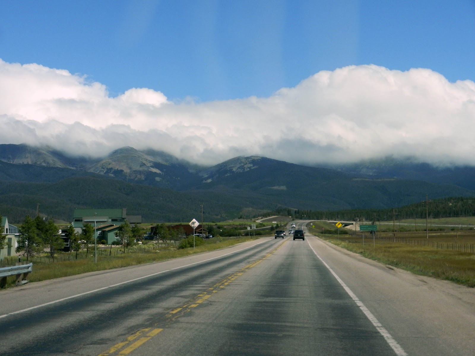
We passed through some spectacular scenery yesterday. Off in the distance in the image below, you can see what our map identified as Mamm Peak at some 10k feet of elevation. And we were going to cross over some very high territory in Colorado.


We also passed by quite a few barns.


Just before reaching I-70, our map identified three state parks just off the road, and we decided to head there for lunch rather than waiting to get to the interstate rest area. We pulled off to the side of the road here:


It was lovely there...and quiet.


Here's a pano of the area.


We had our lunch and our espresso, and then Mike took a short nap. After about 45 minutes, we were back on the road and headed to I-70. As we traveled the interstate, we were shadowing the Colorado River most of the way. We saw some rafters there.


And wow! What a beautiful and spectacular engineering marvel this interstate highway is. We were deep in the canyon carved by the Colorado River.


The width of the canyon cannot accommodate all four lanes of traffic, and so the oncoming lanes were elevated most of the way.


We passed through a series of tunnels.


Eventually, we turned south and headed toward our final destination. We passed through the little ski towns of Frisco, pictured below, and Breckenridge. Both appeared to be right out of Switzerland. I wish I could have gotten a more representative picture, but the one below will have to suffice.


As we got closer to Vail and Breckenridge, we began to see the groomed ski slopes.


In Breckenridge, we could see snow on the mountains. We visited Breckenridge on our last visit to Colorado. If you'd like to see more pictures and learn a little about the town, you can read this old blog post right here.


After passing through Breckenridge (or maybe it was before), we crossed Vail Summit at an elevation of over 10k feet. After Breckenridge (for sure), we crossed Hoosier Summit at an elevation of over 11k feet. The temperature dropped more than 30 degrees when a cold front moved in. We got into some rain as we approached our final destination of Canon City (prounounced "Canyon).


Since we got in well after the office at the KOA closed, I don't have much more to tell you about the local area. Our reason for stopping here is to see the Royal Gorge Bridge. I haven't been outside this morning, but I think we'll be able to see it from our site here at the RV park. Here's what Wikipedia has to say about it:

The bridge crosses the gorge 955 feet (291 m) above the Arkansas River and held the record of highest bridge in the world from 1929 until 2001 when it was surpassed by the Liuguanghe Bridge in China.

China!!! (Shakes fist.) So there's some business to take care of this morning; namely, checking in at the office for any information about seeing the bridge. I believe there is a train or a shuttle or something, but I don't know much as I'm writing this. We have a much-needed day of rest from driving today. I'm going to do some laundry, and we'll do some sight-seeing. Also, I'm going to catch up on my email. So many of you have left friendly and supportive comments, and I've had little time to get back to you. Today I'll catch up. Breakfast awaits. Time to get going.

9/13/13

Street Walkers

We started working Plan B today. Plan B starts with us taking a day off from driving hundreds of miles for the first time this trip. It's true we spent a day in Rocky Mountain National Park and drove the Trail Ridge Road through the park without the trailer attached. Nevertheless, it was over a hundred miles to Grand Lake and back. We weren't anticipating making the same drive with the trailer the very next day, but I suppose that is when Plan B actually started. We drove to Breckenridge, CO yesterday, and we were anticipating moving on again today.

When I checked in at this RV park, I inquired of the little twit sitting behind the desk if there was an option to stay an extra night. (It was raining, and we weren't sure we wanted to.) She said "No, we're kind of booked up." The "kind of" part of that statement was troubling to me, especially since she didn't even glance at her computer screen to see if there were any vacancies.

"Really?" I asked. "Why would that be? You have over 200 spaces, and there is no snow in the mountains. So what is the attraction?"

"Well, there's stuff going on, Octoberfest, and all."

"Hm." I said. "I suppose that makes sense...in September."

As it turns out Octoberfest actually *is* going on this weekend. Nevertheless, Mike and I were highly skeptical of this filled-to-capacity claim when we saw how many empty spaces there were. So, this morning, when we woke up to blue skies and sunshine, Mike decided to give it another try. The twit was still there, but somehow Mike's commanding presence (not) enticed her to check her computer screen again, and lo and behold, our exact space was available for another evening. Go figure.

So that, my friends, is how we ended up having a day of no long-distance driving for the first time this trip.

Breckenridge is a cute little town, a ski resort community, with the thriving economy that goes along with a healthy dose of tourism. It is also a historical town. The town traces its roots to the gold rush, when prospectors panned gold from the Blue River in 1859. Some 250 historic structures reminiscent of the mining era are preserved in one of Colorado's largest National Historic Districts, and the charming Main Street houses galleries, shops, restaurants, and nightspots that inhabit colorfully restored Victorian homes.


Today, we decided to take a stroll along Main Street. We used up every bit of sunshine when it started sprinkling on us as we returned to our car.

We were able to park in a large public lot (free in summer) and make our way to Main Street. Along the way, we passed this monument.


At first, I thought it was a monument to the intrepid skier, but then realized that this particular skier was carrying a rifle. Turns out it was a monument to the American Mountain Soldiers from World War II. 


Mike and I watched a documentary about these soldiers once, and the tiny print on the sign correctly stated that some of the soldiers had been trained at our neighbor to the north in Washington, Mt. Rainier.


As we continued on, we noticed these white bumps on some pine trees. Now, what does this look like to you? We think Breckenridge actually decorates its trees with fake snow when none of the real stuff is available.


There were some wonderful shops along the way. I went inside this next one. It was selling reclaimed items from farms and other vintage structures, like doors and windows, and a whole lot of other wonderful junk.


I didn't see anything I wanted to buy, but it was sure fun to walk around looking at stuff. I saw this, and I knew you'd want to see it too. A vintage row of log cabin blocks framed behind glass. 


Back out on the street, we saw this hummingbird (to the right in the image) sipping nectar from the many flower pots lining the street.


At the same spot, we also spied a Sphinx Moth, also apparently drinking nectar. This sucker was big, and at first, I thought it might be a bird. I tried to get a picture of it, but it was so quick that my picture was blurry. 

It's body was approximately the size of the first two joints of my index finger, and its wings moved fast like the hummingbird.

Most of the structures on Main Street had been beautifully restored, but a few had not. This one, for example:


I'm hoping you can read what the sign above the door says.


MUSEUM
Office of Wm. Pollock
1862
First Clerk and Recorder
Summit County

Cool, huh? Here is another.


This next building was restored, but still wore it's corrugated metal siding.


We noticed that all the fire hydrants had flags, presumably so that they can be located in deep snow. We are at 9,600 feet of elevation, and so I'm guessing there is lots and lots and lots of snow here in the winter time.


We also stopped in at this little shop called "Magical Scraps". What a cute little shop. It seemed to be owned by a young woman who made her living making and embellishing items for sale. She has a website right here where you can see some of her things. I ended up getting tiny leather hand bag that was lined with some of her scrappy fabric...it's sort of like a fanny pack, but has a long strap so that I can wear it over my shoulder.


She had lots of cute stuff for kids of all ages...even big kids, like me. I wish someone would make one of these sock monkey hats in adult sizes. I'd be having me one of these if they did.


She also had a small supply of fabric...very cute stuff that she uses in her sewing, but it was also available cut from the bolt.


We had lunch at a nice little cafe where we sat outside and had a view of Breckenridge Mountain (elevation about 14,000 feet) and the ski slopes.


Today the windows of the many Victorian structures caught my attention, and I found myself taking pictures of them. Maybe I'll start a window quilt one of these days that could go with my door quilt.


If you look at this image above, you can see that some of the unrestored buildings are sided with what we now use as waterproof roofing material with brown wood siding beneath.


After walking up and down both sides of the street, we returned to our car. On the way, we passed "The Dredge" floating restaurant. This is a replica of a dredge that operated on the river during the early 1900's.


This is what the restaurant website has to say about it:
From the early 1900`s up to 1942, there were a total of nine dredges operating in Summit County. Once there was a railroad, there was capability to build these huge dredges. The boilers alone, weighed over eleven tons and were shipped from the east coast, while the timber came from Oregon.
This two million pound floating restaurant is a replica is one of the largest and longest operating dredges in Breckenridge. It was the last dredge operating and stopped forever in this pond in 1942. Its remains are entombed in the silt below us right now.In 1933, starting near Watson Avenue, The Dredge slowly moved through Breckenridge, operating continuously night and day until the end of 1935. Without profits to keep it alive, The Dredge lay idle.
With no maintenance and care, it sank in November of 1937. In 1939 The Dredge was again resurrected by the lure of gold and eastern financiers and was renamed Blue River No.1. It began churning from its sunken location near Washington Avenue and it landed in its final location-here! Later, it was partially dismantled with the last of its remains sinking in 1966.

So with that, we returned to the trailer, and we've just been hanging out the rest of the afternoon.

Tomorrow, we're going to check the forecast in Montrose, Colorado, which is where Black Canyon of the Gunnison National Park is located. The forecast has not looked very good, and we are loathe to drive into any more rain. If it doesn't look any better, we'll skip that stop and continue onto Moab, Utah, where the weather is looking great.

9/12/13

Breckenridge, CO

What a day it has been. I posted earlier today about the rain, and it has been all over the news. We were bored, and so we decided to drive into town (Estes Park) just for something to do. As we went, we were alarmed to see the erosion of the roads in the RV park with whole sections of asphalt washed out.


As I was taking this picture, a park employee rode up on a golf cart and Mike asked him about conditions. He told us the entire downtown area of Estes Park was flooded and that he believed all roads in and out were closed as well. That was even more alarming since we had visions of being stranded for days or even weeks.

We continued on into town and got our first view of the river. I'm posting a video below. If you can't see the video, then click right here. If not, you'll just have to take my word for it that the river was raging, and at this location, it hadn't even started flooding the roads. 


Indeed when we got into the main part of town, roads were closed off, structures were half submerged in water, automobiles were stranded, and it was quite a mess. We drove past the police station and decided to go in and ask about roads getting out of town. As it turned out the road through the national park was the only avenue out, and there was no guarantee it would continue. We were advised to check at the ranger station to be sure.

So then we really got serious about getting out of town. We drove up to the park entrance and spoke with the ranger. He advised that it was foggy at the top, but that the road was still open. Fortunately, we had driven it the day before and so Mike felt confident our rig could handle the winding road and the elevation, which it did with flying colors. When we crossed over the summit and began our descent into the valley on the other side of the mountain range, it was like a different world.


We stopped at the last visitor's center on the way out of the national park and found this sign posted on the door.


So, we made it, and we were glad. Things were only going to get worse in Estes Park. The next question was, what do we do now? Obviously a complete change of plans was in order, and we just kind of drove on with no particular direction in mind. We felt that southwest was our best bet, but none of the weather forecasts looked particularly promising. We decided to head toward Moab, Utah, a place we've visited before and always said we'd like to go back. At this point Pike's Peak and Great Sand Dunes National Park are off the agenda.

We were headed toward I-70 and had two ways to get there. The straighter road took us toward this cloud formation:


The winding way took us toward this cloud formation.


Just then a song popped into my head:
Blue skies smiling at me
Nothing but blue skies do I see
Bluebirds singing a song
Nothing but bluebirds all day long

Never saw the sun shining so bright
Never saw things going so right
Noticing the days hurrying by
When you're in love, my, how they fly
So I guess you know which way Mike chose. As he put it, "I'm not heading into that mfer."

We weren't quite finished with the rain, and in fact, it's raining as I write this in our new home for the night of Breckenridge, Colorado. We drove along the timberline for quite some time before making a descent.


You may be aware that there are lots and lots and lots of mountains in Colorado. Sometimes you drive over them, and sometimes you drive right through them. We were pretty excited to come upon the Eisenhower Tunnel


This is what Wikipedia has to say about the Eisenhower Tunnel:
With a maximum elevation of 11,158 ft (3,401 m) above sea level, it is one of the highest vehicular tunnels in the world. The tunnel is the longest mountain tunnel and highest point on the Interstate Highway system.
Woot! We do get excited about tunnels!


And that sucker was long.......


And there you have it: the official light at the end of the tunnel!


After that, we drove down a looooooooong steep grade, possibly 8-10% for six miles. One of the signs after a runaway truck ramp advised truckers: "Don't be fooled, Truckers," meaning it was still a significant distance steeply downhill. The valley below looked very promising.


And that is essentially where we ended up for the night. We're now in Breckenridge, Colorado for the night, and tomorrow we will continue on our way to Black Canyon of the Gunnison, weather forecast permitting.

We've had a chance to study the maps, and after Black Canyon of the Gunnison, our plan is to continue on to Moab, Utah, where we can see both Arches and Canyonlands National Parks. We've visited both parks before, but we've talked about going back many times. After that, there is some beautiful country leading down to Zion. And with Zion, we'll be back on our original route. I'll tell you more about that as we get on our way.

So phew! A happy ending to a day that could have been disastrous. We are sorry the weather was so poor for our first (and probably only) visit to Rocky Mountain National Park, but we are very happy not to be stranded there in that terrible weather.