Good morning, my friends. Let's go have some fun. We got a good night's sleep despite car alarms going off in the middle of the night. Yeesh. How embarrassing. Glad it wasn't us. We were up and out fairly early to drive Shafer Canyon Road. It's the same road we took when we rented a Jeep some twenty years ago.
Heading out of town, we crossed over the Colorado River.
And then turned left just about a mile later. We drove alongside vertical cliffs on one side...
and the Colorado River on the other.
Reaching the end of the paved road, we started here on Shafer Canyon Road. It's a dirt road all the way, rocky and rugged in certain areas. We're riding at the bottom of the canyons of Canyonlands National Park here, and we'll be heading up, up, up until we reach the top...a distance of about 18.2 miles.
We first came to this balanced rock. It was about twice the size of our Jeep.
I found this larger aerial view online.
(Image credit: "Evaporation Ponds" by Jesse Varner is licensed under CC BY-NC-SA 2.0.)
Continuing on, we saw more small arches and balancing rocks.
Here, we came upon this towering monument. Everything is immense here, and that "tower" rises high above the desert floor.
Please keep your woofies under control here. We didn't see any bighorn sheep, and of course it's too late in the year for lambing.
Continuing on, we came to this stunning view of the Colorado River. This happens to be the "Thelma and Louise" point. And if you've never seen the movie, you should.
Here, I like these echoing pinnacles.
We wanted to recreate this next image we took on our first ride through here around 20 years ago.
It took us a while to find the exact spot based on the bend in the river and the surrounding landscape. And this is it. It looks a little different 20 years on. There's a beach below now.
There were some rafters there.
Turning around from that spot where Mike was sitting, I took this picture to give you a sense of the scale of the surrounding landscape.
We had hoped to recreate the image below too. I was lying there on a natural bridge. The natural bridge is about six feet wide, and so this wasn't a scary proposition...especially when one is lying down.
When we came to the end of the line, we realized we'd somehow missed the natural bridge. As it turns out, it's no longer possible to get out to this formation, known as "Musselman Arch." It's named for a man who did extensive exploring in the region, but it is not an "arch." It is a natural bridge. Here's another picture of it so you can get a better look at how high off the canyon floor it is.
(Image credit: "Musselman Arch" by Adam Zolyak is licensed under CC BY-NC-ND 2.0.)
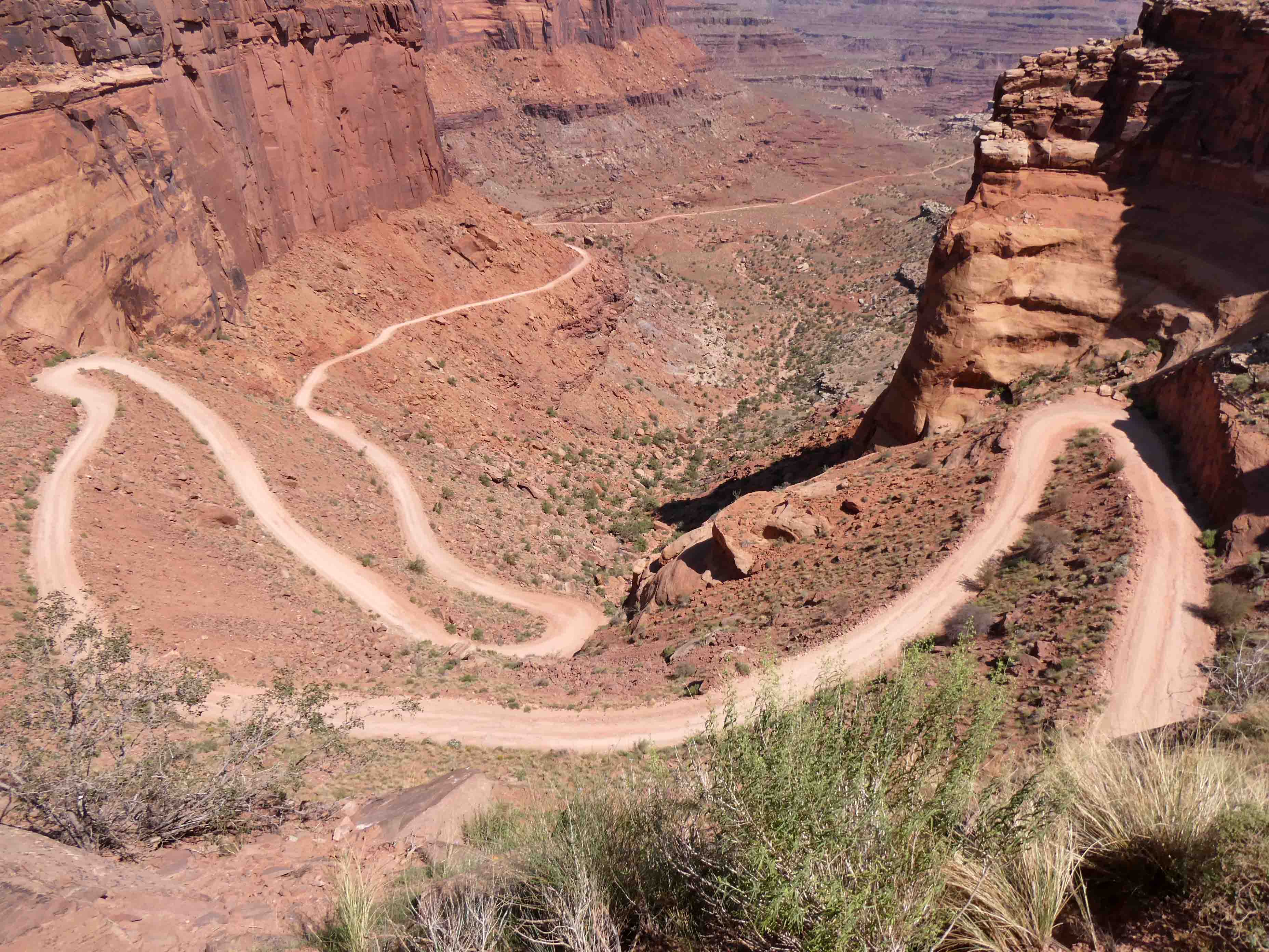
We drove a winding trail of switchbacks. This is the image from our navigation app. Check out the section toward the bottom of the image.
Our route took us in and out of the national park and BLM lands. Eventually, we crossed into the national park proper. Mind your manners, please.
Here we passed by some small hoodoos. This is the sort of thing one sees during a visit to Bryce Canyon National Park.
And there goes the road, up, up, up.
Here, I stuck my camera out the window, pointing up. The cliffs are vertical here.
Nearing the top, we stopped for this image. That's the road we came in on.
And we paused for one last picture here, before reaching the paved road of the national park.
If you look in the middle of the image, you see some landscape that is nearly white in color. That is White Rim Trail, and that is the road we would have needed to take to reach Musselman Arch. It requires a permit, which we didn't have, and we've learned that one can no longer walk out to the arch. The Bureau of Land Management recently put in new restrictions to where vehicles (and people) are allowed to go. It's to protect the environment, and we're all for that. Nevertheless, Musselman Arch and Gemini Bridges...two venues we've visited in the past...are now off limits.
Reaching the paved road, we were inside the national park. The visitor center was just about a mile to our left. We checked out the visitor center in search of a shot glass. They had none, and I already have a refrigerator magnet from Canyonlands. They couldn't entice me to buy anything...not even this embroidery kit.
Not even this quilt panel kit.
I was the Queen of Resistance while here.
We've visited this park several times in the past, and so we didn't go farther down the road to see the park. Given the crowd at the visitor center, and the fact that it was Saturday, we fully expected all the viewpoints to be mobbed. Instead, we headed back to Moab, naps, refreshing beverages, and a steak dinner.
Speaking of food, it's time for our Sunday morning pancakes. I was smart for this trip and mixed up all the dry ingredients ahead of time. It'll make for an easy pancake batter. We've not yet decided where we'll travel today. Mike has gone back to bed, and he makes the decisions about those things. I'll have more news and I'll clear up the mystery in tomorrow's post.


7 comments:
Of all the paths you take in life, make sure a few of them are dirt. ~ John Muir
Such amazing scenery!
Some really dramatic scenery!
Amazing and so brave to be on those roads, even with a Jeep. I had one that I loved and did the desert Ca driving. But looking back, REALLY liked being in a safe group. But your hubby is mechanically inclined. Helps. Beautiful and thank you for taking us along on an area we would not try now.
Wow! Even with the restrictions you hit some beautiful places during your drive.
I love your travelogue. The best.
What a fun drive with great views. Fun to see the photo recreate, too - and how much the landscape has changed.
Post a Comment