We waited until late morning to take off on yesterday's ride. It has been much cooler here in Silverton than it was in Ouray. The elevation probably has a lot to do with it, since we are at least 2,000 feet higher. When we left, the kitties were all wrapped up in quilts and ready for their morning naps. As I mentioned, the kitties are always up before the sun rises, and so morning naps are a welcome respite from their hard work as furry alarm clocks.
Sadie is not interested in discussing this. Please do not disturb.
As we headed out, I snapped this picture of Kendall Mountain, the trail we road the previous day. It's hard to get a good picture of it because of the bright sunshine in the morning. On the other hand, when I waited until afternoon, it was cast in shadow. This is the best I could do. I messed with color and contrast to try to bring it out. The Durango-Silverton railroad runs right at the bottom, and there are some box cars lined up there that probably have nothing to do with the D-S railroad. I'm only showing you because we rode to the tippy-top of the mountain on our first ride, zig-zagging back and forth to reach it.
Below, and alongside the railroad tracks, is this wheel. It appears to have nothing to do with the railroad. My friend Carol asked her Colorado peeps what its function might be. The consensus is that it probably held a cable for a tramway that transported ore from the mine to the railroad below. Makes sense to me.
So, off we went, riding through town on our ATV's and sharing the road with cars. The speed limit is 15 mph through town and then just 20 mph to reach the Mayflower Gold Mill. There are self-guiding tours here, but we didn't do it. I have an idea there was a price tag attached, and we had other destinations in mind. Still, it was interesting to see it. I'd always thought of "mills" as places where grain was ground into flour or meal of some kind. Apparently mined ore is also processed at a mill.
This area I'm going to tell you about today is known collectively as the Arrastra Gulch.
If you're interested, you can read the sign that follows. For these images, I broke it up into four sections for readability. You can make the images larger by clicking on them, so read if you like. Or, if you don't like, then you can just look at the pictures.
This next map is associated with the image that follows.
Here's how the town once looked. We rode alongside the Animas River for much of the day.
In this next image, you can see the tramway and buckets that transported mined ore to the mill.
They stretch all the way across the valley and to the hillside where the mining operations took place.
Just a little farther on was Howardsville. It was the first attempted settlement of the Western Slope of the Colorado Territory. What I learned on yesterday's journey is that the towns associated with the mills are mostly completely gone, and the mining operations consist mainly of ruins. You'll see as we go. The signs are included so you can see pictures of the area as it once looked. So here's some information about Howardsville:
Here's how the town once looked.
Here is what remains of it:
The tire swing was a curiosity. One wonders if it is a modern addition, but it looks old to me.
I thought this might have served as a privy at one time, but looking inside, there was nothing to indicate that.
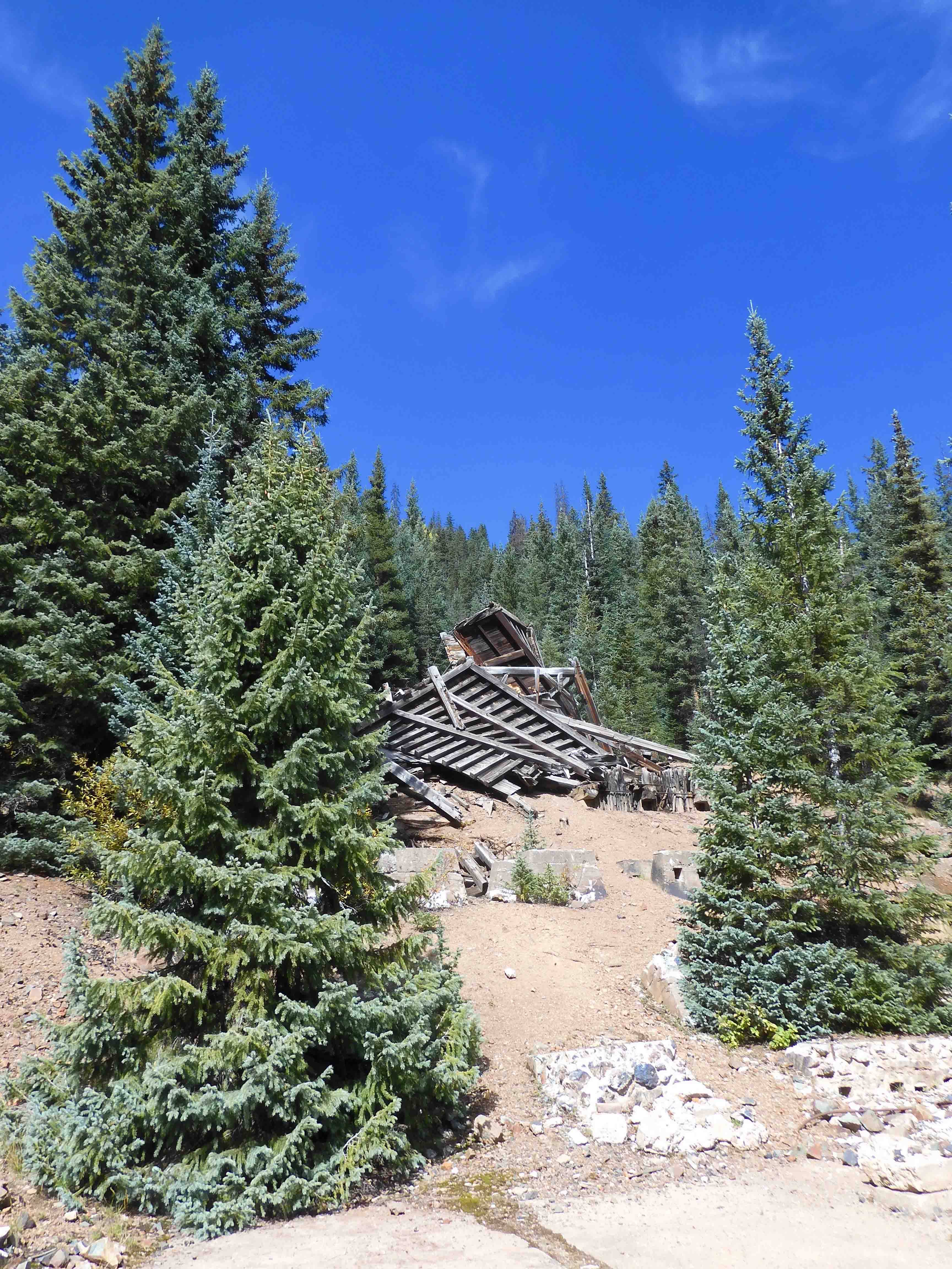
Riding on, we passed by this abandoned structure. We were headed to the Eureka Mine.
Here is all that's left of it. I tried to get some more information about it and found
this interesting link about the history of the town and the mine. If this sort of thing interests you, it's worth clicking there to find out more. This was once a thriving community, but it is all gone now. At least one structure has been renovated, but the rest has been turned into a campground.
Looking up at the hillside to the right, it looks like this:
Across the valley was a pile of tailings from the mine. We saw a lot of this. Those are our ATV's on the left.
To the left was this mine shaft.
It was a pretty view from here. Unbelievably there were some other folks there and one woman was picking up stuff from the ground and loading it into a bag for removal. This is a violation of the Antiquities Act. When Mike informed her it was illegal, she apologized and put it back. Sheesh. What are people thinking?
We rode on up the trail leading to the mine itself, and this is all that was left of it.
We paused here to get our bearings, check the map, and decide where to go next. Then we rode back the way we came.
We decided to take the Minnie Gulch trail. We were amused to find some snow boots at the bottom of the sign.
Riding on, we came to the remains of the Caledonia Mill. I could find almost no information about this, but I did find this one
link with a few basic facts. They were mining for zinc, copper, lead, and silver. It was a pretty site, nestled in among the aspen grove.
A little farther on, we came to the Caledonia Mill Boarding House.
You can
read a little more about it right here. I'm not sure what that structure is on the right in the image above. In modern times, I might think it was a hot tub, but my guess is that it was a sistern.
Walking around to the other side...I've seen pictures online taken before the windows and doors were boarded up. It now holds a "no trespassing" sign, and the wood appears unstable and rotten.
We were passing through an aspen grove. It seems fall has arrived in Colorado.
Riding on, this structure once served as a tram station bringing ore to the mill.
Above and at the end of our ride was the Kitty Mack Mine. I could find almost no information at all about this.
We were at the end of the trail here, and we marveled at the work that went into these mines when there was no railroad nor, indeed, any roads at all. We weren't sure about electricity. This was the early 20th century, and so we think there probably was electricity for industrial purposes, most homes were still without it. There was one tower with what might have carried electrical wires, but they were disconnected now. It's the sort of thing that could cause a wildfire in this warming-planet era.
From there, we headed back down the mountain, enjoying the aspen groves as we went.
We stopped for pictures of this structure.
It appears to have been someone's home, but I don't know any more about it. I set one foot on the rickety front porch to take a flash picture of the interior.
This structure was to the right. Perhaps a place for smoking meats? Or storing canned goods? Hard to know.
Even when your goal is not grand vistas, you can't help but find them everywhere.
Here, I zoomed in on that stand of aspens.
And that was our ride for the day.
We have one more day in Silverton before moving on to Bloomfield, New Mexico, tomorrow. We've decided to take a break from ATVing for the time being. Riding over the rocks on these trails takes its toll on one's body. I've been whining about my neck, although my shoulder and thumb have held up well. Mike was complaining about his back yesterday. It seems as if our age is catching up with our capacity for adventure. We'll do some more riding in Oracle, Arizona, but that stop is more than a week away. By then, we probably will have forgotten how old we are.
We'll spend most of the day doing "life" things. We have a pile of dirty clothes that need laundering. First, we'll make a stop at the bank for a roll of quarters. Everywhere we've been, we've found the price of a washing machine at $2 for the wash and $2 for the dry. You can go through a roll of quarters pretty quickly at that price. We want to spend a little more time in the town of Silverton. There are a couple of gift shops I want to revisit, and we'll get one more funnel cake for our dessert tonight. There is a small grocery store in town, and we'll pick up a few things there too. A day of rest is always welcome, but it doesn't mean we won't find ways to fill our time.
There are too many woofies and people here, and so Smitty hasn't been out for a walk. We're hoping he'll find greener pastures at the next stop in New Mexico.


7 comments:
The thirst for adventure is the vent which Destiny offers; a war, a crusade, a gold mine, a new country, speak to the imagination and offer ~ Jose Bergamin
Quite a community back in the day. Amazing to me to think of all those people working so remotely, with many doing really hard labor. But oh so beautiful a place although it does look a wee bit cold. Good to see the kiddies sleeping under such beautiful quilts to keep them warm. I look forward to hearing about your adventures in New Mexico, as well as Oracle.
Really enjoying your travel photos and observations. And, as is often the case, appreciate the belly laugh from your clever wit: “ By then, we probably will have forgotten how old we are.” Pure gold! 😉
This couple lives in Ouray and does a lot of hiking on the peaks. Sorry I didn’t show at this link sooner. Pretty sure you wouldn’t be hiking, but some of the history they mention might have been of interest. https://boxcanyonblog.blogspot.com/
—Annette in Omaha
What a fun day of riding, but I can see how it would be hard on the body. I've enjoyed seeing the structures and the vistas, though. Thanks for sharing so many great photos!
I can certainly identify with the ATV riding taking a toll on the body!! My neck hurt so bad when we were in the Black Hills this summer that I had to seek out a Chiropractor. But oh the beautiful country one can see on the ATV that you don't see in a car:)
Yet more amazing things to see and marvel at. The aspens are beautiful - not trees that are prevalent here. Of course I loved seeing the old structures and wondering at the reason why they are now abandoned.
Post a Comment