

When we realized the rockiness of the hike, coupled with high steps up and down, Mike went back to the truck for my hiking pole. My knee can handle this level of hiking, but the pole gives me better stability and more confidence.

It's possible to hike to the top of Picacho Peak. There are two different trails: Hunter Trail, which took off from the same spot. Also, Sunset Vista Trail, which can be reached from our campsite. Both trails are rated as "difficult." Also, "The route is steep and twisting, with steel cables (gloves are recommended) anchored into the rock in places where the surface is bare." Okay, well that was a little too much for us to commit to. Here's what we did. We took the red arrows to the overlook, then followed the green arrows back the way we came and took a spur hike to the Nature Trail before heading back to the truck.

It ended up being a hike of a little over two miles and 34 flights. While I waited for Mike, I took this panorama of the area surrounding the trailhead.

Also, I noticed the Ocotillo cactus are greening up and getting ready to bloom.

So far, we haven't seen any actually blooming here in Picacho Peak State Park, but I have some images of blooming Ocotillos from a previous visit to Organ Pipe National Monument, which is about 100 miles southeast of here.


We were about halfway to the overlook when we stopped and looked back. You can see the campground far off in the distance. We are parked on the far side.

Also, we noticed this Homer Simpson cactus.

From the top, we could gaze out toward Tucson, Arizona.

Here's a panorama from the spot where we sat on a bench and ate our Clif bars.

On the way back down, we noticed this cactus having a bad hair day. This is how I feel in the morning.

There's an amazing variety of cacti to be found in this park, and just a few hundred feet of elevation can make a big difference in varieties. We noticed more of these barrel cactus with their red barbed needles. You wouldn't want to fall into one of these suckers.

Here we peeled off onto the Nature Trail.

And there, we noticed this bird's nest built on the arms of a teddy bear cholla. My friend CJ tells me that this is undoubtedly the nest of a cactus wren. It's the same bird we saw perched on a saguaro cactus in our wanderings through the campground.

I believe this little fellow is known as a hedgehog cactus. With names like "teddy bear" and "hedgehog" one might think you could cuddle up next to them, but I'd probably avoid that if I were you.

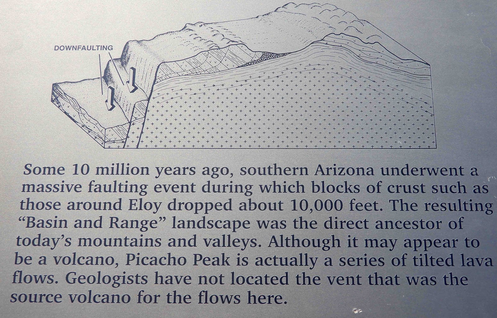
There was some signage along the Nature Trail explaining the geology of the park. You can read it if you're interested.
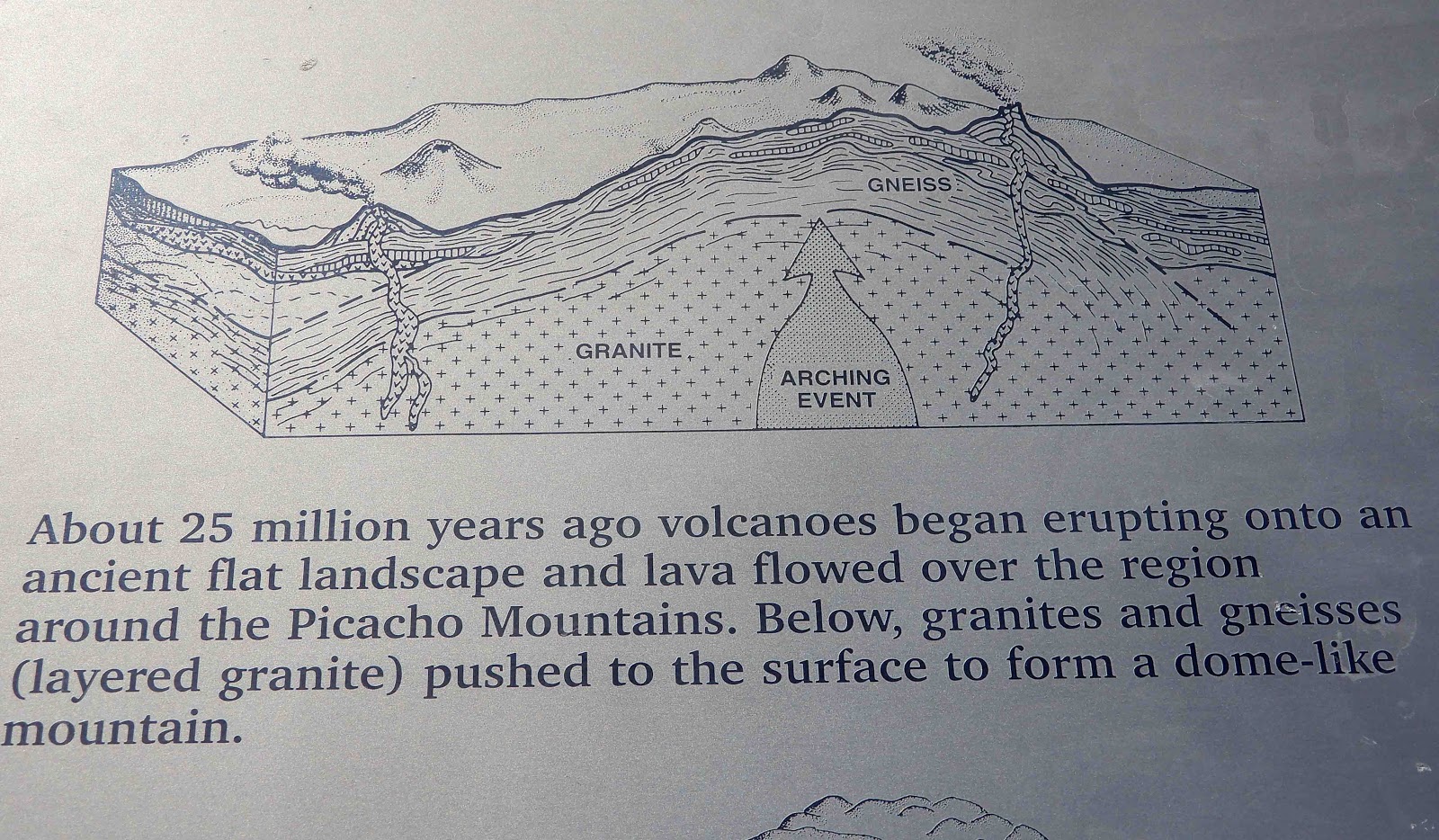
Sorry about cutting off the left side of the image below, but I think you can still read it.


When we got back to the RV, the wind picked up and it blew like crazy all the remainder of the day. In New Mexico, we were facing into the wind. Here, we were catching it full force from the side, and it made for a rather uncomfortable afternoon. We were glad to have been out earlier before the wind picked up.
Today we're heading for Blythe, California. I was just about to type that there's really nothing to see in Blythe when whoa! I found this information about the Blythe Itaglios. These are anthropomorphic geoglyphs located in the Colorado Desert. Who knew? And if "anthropomorphic geoglyphs" too much of a mouthful, here's a picture of what I'm taking about. This image was taken from a Google satellite.

There are 6 total figures in 3 separate areas, believed to have been created by the Mohave or Quechan Indians somewhere between 450 and 2,000 years ago. Two large man-like drawings (likely Mastamho, the Creator) and a some smaller animals (likely Hatakulya, two mountain lions/persons who helped in the Creation) stretch up to 171 feet (~52 meters) in length across the desert floor. In my searching for more information about them, this link from Ron Kilber's Log had the most complete information and pictures.
So...I don't know if we'll get there or not. It's the sort of thing best seen from the air, but you just never know where the Three Cats Ranch Traveling RV will end up. To get back to what I was saying, we're going there because it's a good length of a day, and there are several free spots to stay for the night. Tomorrow, we'll be at our final resting spot of Hemet before we head for home in April.
7 comments:
Wonderful pictures.
Looks like a wonderful place to hike. Beautiful pictures.
This is a very interesting park and thank you for sharing all the wonderful photos. My youngest son had a thing for cacti and we raised several over many years - even had a few flower.
Beautiful place to hike. I am bad coming down the hills, that is when my knees complain.
Those would be fun to see, hope you can make it there.
Debbie
I like the peaks. Too bad they are too difficult to hike! THere are so many different cacti that it must have been easier to give them simple common names! Organ pipe, Teddy Bears and Hedgehogs!
You find so many interesting places to visit. You should write a book; I think yours would be much more fun reading than Bob & Mary. Enjoy your travels!
Hah! Homer Simpson cactus!!!
Glad you got in a nice hike & sunny weather.
The geoglyphs are very interesting, glad that they are a bit more protected with fencing now.
Post a Comment